 |
 |
||||||||||||||||||||||||||||
|
|
|||||||||||||||||||||||||||||
|
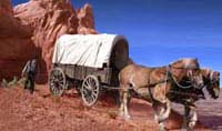
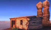
History of San Juan County Chapter I To classify these periods, or determine their duration with any accuracy is beyond our finite minds. Sandwiched into the stratus, as contradiction to the conclusion we would draw, are remains of stately forests whose petrified trees are projecting from our cliffs, or crumbling on our hills. The hills themselves are peppered with fragments from other rocks, broken off and worn smooth in other ages. And just when in this wonderful story, the Blue Mountains and the LaSals forced their way up from porphyry-bound depths, to be distributing centers for the streams in ages to come, is also beyond our guess. The prevailing forces of those long periods, carved out our canyons, fashioned our mesas, and smoothed old wrinkles wide prairie lands, which answer our efforts by changing from gray to green. From this imperfect glimpse of those interesting operations, we come down indefinitely to the time when men began to live in our caves and later to build their stone houses on our bluffs and out hills. And here again we must be content with our fond and fallible guesses, as we gaze at cliff-faces of hieroglyphics, and time-worn steps leading up to the impregnable walls. The shattered fortress keeping mute sentinel over the pass or crossing, and the white skull still holding the axe that split it in twain, hold alike to their coveted secrets. We know that a nation left their castles to crumble and their farms to grow wild with cedars and brush; and though we gaze longingly at the worn lintels and marks of human fingers in the mud-daubed wall, we are forced to give it up as a sealed volume. The next clue upon which we eagerly pounce, is the legendary history of Utes and Navajos; bloody battles along the San Juan, as the two red races struggled for supremacy-invasions of Ute territory by Navajos, invasions of Navajo territory by Utes. The fought all day at Peak City, and each race withdrew in the evening to its own side of the river, which was swelled before dark with a raging flood. The Navajos relied on the flood to protect them, and fell asleep. The cunning Ute chieftain watched the stream as the night advanced, and when it fell he crossed over with his braves, surprised and beat the Navajos and took a great many of their women as hostages back to the Blue Mountain. That is, of course, a Ute version. A Navajo story relates how they crossed the river in the vicinity of what in now Bluff, stirred up a quarrel with the Utes and crossed back in hot haste to their own side. When the Utes followed in a long angry string, the Navajos hid behind rocks each side of the trail and biding their time, took the Utes in a cruel trap, shooting them from all sides. Comb wash and Elk Mountain figure as strategic trails and points of advantage on the Ute side, while Navajo Mountain is always the last impregnable resort of the Navajos. It was to this wild region in the year 1879 that President John Taylor of the Mormon Church called a company of settlers, to cultivate the good will of the Indians and preserve law and order. No wagon road led into the country from any directions at that time, and few men knew what sort of scenery they might expect to find in the strange territory cut off from Utah by the yawning Colorado. That the Utes and the Navajos maintained undisputed claim to the country, was generally understood; and if an outlaw wished to baffle all pursuit, he had only to make friends with the Indians to accomplish it in San Juan. Even in Utah so little was then known of this country, that an exploring party was called to hunt it up, and find a way into it. The personnel of this party, and their adventures, constitute the beginning of our real history. Right here let us get San Juan fixed in our minds as the south-eastern corner or Utah, fenced off on the west by the Colorado River, bounded on the south by Arizona, on the east by Colorado, and cornering on New Mexico. That is the only place in the United States where four states corner together and we shall see that San Juan has been and is, unique in other respects, that it is peculiar to itself, different from any other section in the United States or in the world. CHAPTER 2 The company called to find San Juan were from Parowan and Cedar City, Utah, and they started from the latter place April 14, 1879. Among them were President of the company, Silas S. Smith, James B. Decker, Parley R. Butt, Kumen Jones, Hanson Bayles, H. Joseph Nielson, Zachariah Decker, Robert Bullock, John C. Duncan, George Perry, George Urie, Thomas O. Bladen, Ham Thornton, John Butler, John Dalton, James Adams, Adelbert McGregor, Isaac Allan, Jesse J Smith, Albert Smith, Steve Smith, George Hobbs, Harrison Harriman and James L. Davis. The last two had with them their families; twenty teams, perhaps half as many wagons and a few loose horses and cattle made up the outfit. The object of their journey lay eastward, but they headed south for Lees Ferry in Arizona, the nearest known crossing of the Colorado River. From what is now Moab, to that distant ferry, no one had yet shown modern man the way over. Leaving the ferry about May 2, they found a road to Moancopy, or Tuba City, where they rested their teams while they worked for John W. Young on a woolen mill he was building. But the road went no further. From Moancopy they looked on to the north-east, over dry mesas and glistening sand hills, where the Navajo guarded his sheep and goats in a wilderness all his own. Leaving their loose stock, the hired and old Navajo and a man named Tanner, to pilot them over to the San Juan. At one place in the desert, the only water was claimed by Peokon, who insisted there was barely enough for his own herds. He refused the jaded teams a drink, and when some of the boys insisted, he struck savagely at one of them with a club. Twenty young men full of fire and sand were hardly the combination to endure this tamely, and a strained situation was relieved when their President suggested they dig a well in the sand. They dug several wells, found water at an easy depth, supplied their animals, and the next morning presented these new sources of drink to the Peokon. The old man accepted them in silence, and became a friend, though he had made a pronounced beginning as an enemy. Other similar instances proved the efficiency of S. S. Smith, who steered clear of trouble without yielding his purpose. He formed among his men a military organization which kept them in order, and increased their effectiveness as a body. One evening a horse, having been kicked, was found to have broken a leg and had to be killed; twenty minutes after the shot was fired, the waiting Navajos had the carcass sliced up and on the fire to roast. They ate it all. Hunting out a way for their road, and building it, or at least making it passable as they went, the company’s progress was necessarily slow, and accomplished with hardships which are always about in a desert or gulches and sand dunes. Kumen Jones, the 23 years old, acted as scout and fore-runner in finding the road and the water. Towards the San Juan the met Peogamet, a pretty Ute chieftain, who, having heard of their approach, came out in hateful temper with his braves to turn them back. Be it remembered the Utes claimed the territory north of the river, and we shall see that they yielded it with reluctance and stubborn protest, as the pressure of later years came to bear upon them. Peogament and his men were ugly in looks and speech appeared to be suffering with womt loathsome disease. But the Mormon President was wise and firm in his leadership; with all possible grace, and all necessary resolution, he over-ruled the chieftain’s objections, and arrived on the San Juan June 1, at a place since known as Allan Bottom, sixteen or eighteen miles above what is now Bluff. Coming down from those heated sand stretches to the river bank, the recognized in the cool stream and spreading cottonwoods, the first real glimpse of what they had hunted during six long weeks, and all hands fell to fishing. The catch was of white salmon, and one weighed twenty pounds. At the mouth of the Montezuma they found Peter Shirts, a one-time resident of southern Utah, but now a lone hermit, subsisting on fish, and wearing vestiges of clothes which had been. Further up the river they found a man named Mitchell, who, with his family had begun a ditch and a farm. The explorers joined Mitchell in his ditch, flew at the shovelling and the rip-rapping with a vim, and placed claims on all land for seventeen miles down the river. When Sunday came, they organized a Sunday School, with James B. Decker as Superintendent, and regularly from then on, they observed the Sabbath at the mouth of Montezuma Creek, their headquarters, where they also celebrated the fourth and the twenty-fourth of July. From here they sent back for their loose stock at Moancopy, and dispatched exploring parties in every direction. John Butler’s party discovered the creek and the valley which still bear his name. Another company traversed White and Mustang Mesas, and took account of the size, extent, and Streams of Blue Mountain. President Smith and other went into Colorado as far as Alamosa, both to see the country and bring back provisions. Harriman and Davis, the men with families, and one other man, stayed at the mouth of Montezuma, and the remainder of the company started August 13 for home. They followed Recapture Creek from its moth, making fifteen miles of road in the canyon, and then out into Mustang Mesa. They slid into and wormed their way up from Devil and Long Canyons, crossing South Montezuma at what became the Bob Hott ranch. At the forks of the creek, south of what is now Monticello, they found a cabin newly built by men expecting to soon bring cattle into the country, and here they stopped a while to rest. They also camped on Spring Creek, from which place they took excursions on the mountain to prospect, to explore, and to fish. Beaver dams had formed crystal lakes at the base of the mountain, and in them speckled trout were abundant. Of two men sent to find a road down Peter’s Hill, one believed three days would suffice to build it. The other said three weeks. However, they made the road and followed it in half a day to Dry Valley, travelling by way of Looking Glass and Coyote, where a dim track led from Grand Valley to La Sal. At Hatch they found deer aplenty, and relieved their monotonous diet of bread and slickum. A few families had settled on the present site of Moab, and a negro raised luxuriant beans and tobacco in the old Mormon fort. In answer to President Smith’s inquiries, the negro assured him that the entire valley could be purchased for $3,500. The explorers forded Grand River a mile below the present bridge, and travelling by Castle Valley, Salina and Beaver, reached Cedar City about September 17, having travelled more than 1,000 miles, and made 400 miles of new road. CHAPTER III The exploring party had found entrance to San Juan from the south and exit from the north, but no way for its colonizers to approach it from their place in the west. George A. Smith, in behalf of the church had sent Charles Hall to find this direct route, the first and chief essentials of’ which, was an opening to cross the gorge of Colorado. How he happened to miss the favorable places since found, is not quite what became know as the Hole-in-the-Rock, a strange entrance to a hewn notch in the river’s west wall. Through this opening it was reported a road could be built, and hither San Juan’s pioneers were directed to come. They had been called by the Mormon Church from Cedar, Parowan, Red Creek, Holden, Paragoonah, Panguitch, Oak City, Harmony and other places, to start with their families and their stock for the region found by the exploring party. Starting in October, collected late in November at Forty-mile spring in Escalante desert. AT this point they had gone as far towards the mysterious Hole-in-the-Rock as wagons had ever made a track and had struggled up or slid down over many a place which no truthful man could call a road. The company had left their settlements, with provisions for a six weeks trip, and some of them had already been a month on the road. Snow had fallen on them both before and after they passed Escalante, and with their depleted store, they looked forth to the winter, the cavernous moaning abyss of the Colorado, and the strange unknown region beyond it. Bishop Schow and Reuben Collet accompanied them from Escalante to assist in finding a crossing. At Forty-mile, some of the leading men climbed a high point on the mountain nearby, and tried with field glasses to make out something of the country ahead. What little they could see was a revelation, and one of them wrote in his journal, “the few miles we can see, are the roughest that white men ever undertook to pass over.” On November 28, Silas S. Smith, President of the company called thirteen men to find a way down to the river and out the east side. They were A. P. Schow, Reuben Collet, Wm. Hutchings, Kumen Jones, Samuel Rowley, Joseph Nielson, Samuel Bryson, Cornelius Decker, George Hobbs, John Robinson, Joseph Barton, James Riley and Platte D. Lyman. They took two wagons, one loaded with a boat, the other carrying camp supplies. After travelling sixteen miles, over what one of the calls, “the roughest country I ever saw a wagon go over,” they arrived on the second day at the Hole-in-the-Rock, “a cleft in the solid rock.” But the river crawled along 2,000 feet below them, and the “hole” was not big enough to let them through. Prospecting two miles along up the jagged brow of the cliff to where it was less abrupt, they removed the front wheels from under the boat, and lowered it by hand, zigzag downward a mile over and between rugged rocks to a sand beach. Across this sand the dragged their load another mile, and slid it 200 feet over solid surface into the water. After a late supper, they loaded into the boat, and tied it up at midnight below the “hole[."] Next day they tried to find the mouth of the San Juan, and got stuck in shallow rapids. The east side rose up rough and precipitous above them, but it neither being possible to float down nor row up the river, eleven of them strapped their camp on their backs, and climbed out into San Juan county. A bald headed landscape met their eyes. “We found the country so rough and broken” writes on of them, “and so badly cut in two by deep gorges, all in solid rock, that we gave up all idea of a road being made there.” Returning to camp at Forty-mile, a council meeting was held December 3rd in the tent of President Smith. An adverse report was given of the crossing, and of the country beyond. But what should be done? Over many a place behind they had slid down with no thought of ever returning. Their hundreds of cattle and horses had eaten all the grass along the road, leading back to the settlements, and over those settlements hung the paralysing chill of winter. Besides all that, a company of 60 to 80 families had gained too much momentum in a month's travel, to turn before they were compelled to do so. Jens Nielson proposed they leave it to their president, and sustain his decision. The president advised them to go on. Next day in a meeting of the entire camp, it was unanimously resolved to begin on a road through the Hole-in-the-Rock, and report to that effect was sent back by Bishop Schow and Reuben Colet. It took seven days to cover those sixteen miles from thei[r] undertaking, where 82 wagons had collected by December 14, with neither wood, water nor grass, anywhere near. Some of their horses they put down on a shelf towards the river, and they hunted black shadscale in every direction, going out with lasso ropes and bringing in huge bundles like loads of hay. Those bundles, if used economically would furnish a doubtful blaze a whole half hour. On the 14th, President Smith came down from his camp six miles above, and called a meeting in which a travelling organization was effected for the company. He was sustained as captain: Platte D. Lyman as assistant captain of the first ten; George W. Sevy, captain of the second ten; Benjamin Perkins of the third; Henry Holyoak of the fourth; Z.B. Decker, fifth, Samuel Bryson, sixth, with Jens Nielson as chaplain, and C.E. Walton, clerk. But this gives no sure clue to the size of the company for it was increased by arrivals from Panguitch that evening. The President, having looked down through the narrow opening, returned on the afternoon of the 14th to Fifty-mile, and from there to Parowan, for the purpose of including the territorial legislature to make an appropriation for the road into San Juan. However, he was gone all winter, and Platte Lyman acted as captain the remainder of the trip. The Hole-in-the-Rock was too narrow to admit a wagon. The first third of its slope fell eight feet to the rod, but farther down the pitch moderated, and ended in a fairly level landing. This straightened passage, and several perpendicular ledges below it, constituted the immediate problem of the company, with their diminished provisions, and their lack of much that was necessary to make a road to the river. But that company of Mormons like their prototypes who danced at their camps on the plains after travelling all day, were filled with one thought more than any other, the thought of success. They took their hungry horses back ten miles from the river to find grass, they ground horse feed into flour with coffee mills, and they ate parched corn with their gravy, or with their bread, or with their water, and some of them ate it with nothing but a relish. In the camp was a fiddler, Samuel Cox, a jolly good fellow wearing leather breeches. In the evening, after working hard all day on the road, they collected ropes and ropes full of shadscale, to illuminate the ballroom, and they danced on the smooth rock, while the melody of Brother Cox's fiddle floated away over the yawning chasm of the Colorado. CHAPTER IV From the top to the bottom of the Hole-in-the-Rock, was about 100 feet; between the top and the river was a drop of 2,000 feet though the distance was but three quarters of a mile. Those pioneers still affirm that the distance from the river to the top was ten miles. By December 17th, forty-seven men had settled down to work on the road, widening the cleft, and filling it in with sand and rock from above. That same day George Sevy, Lemuel H. Redd, Sr., George Hobbs, and George Morrill, having been chosen for the task, started with a pack outfit to explore the country ahead to the mouth of Montezuma Creek. Four less determined men surely would have failed at such an undertaking, even if they had not perished from cold and hunger. Passing the most distant point to' which the eleven former explorers had gone, they headed off to the north-east through a country, rock-bound and cheerless where steep hills of smooth sandstone, or deep echoing gulches kept them turning to right and left to find a way out. The name and number of the distant point and corners from which they had to retrace their weary steps, may never be known. Forty miles on their journey they found Clay Hill pass, the only opening suited to their journey, through the mighty reef reaching from Red Canyon to the San Juan River. Forty miles farther on, in this trackless, snow-covered wilderness, they headed for Grand Gulch at the foot of Elk Mountain, and turned eastward through the dense forest towards upper Comb Wash. Somewhere in this strange wilderness, their weary animals wading through deep snow, a blinding snow closed in around them. With a limited supply of food, and no grass, they hardly dared to stop and house in, but tried to push on to the lower country. Four or five days without sun or star or mountain peak to guide them, they wandered on in vain. When they reached Comb Wash, east of the great cedar forest, the horizon, new and strange, revealed no familiar land marks. Worse still they had no more food left in their water-soaked panniers. They had all but decided to butcher one of their mules, when they came to Navajo Trail, the only possible place in many miles to climb over the peculiar barrier east of Comb Wash. From the top of the trail, Hobbs recognized the country, and traveling eastward twenty-five miles, the arrived at the mouth of Montezuma Creek, where they found the Harriman and Davis families in a destitute condition. After resting a day, they turned again for Hole-in-the-Rock, reaching camp January 9th, having travelled 310 miles. They reported it possible to make a road, and thought nothing ahead would be as difficult as the country adjacent to the crossing on the Colorado River. The storm which closed in around the four hunters, brought wind and snow to the camp of the pioneers. Their horses humped up and grew poor and some of them, cut and bruised by the rocky places through which they were driven by remote patches of grass lay down to rest, were unable to rise, and had to be killed. But the owners of those unfortunate creatures, would thank no one for drawing a melancholy picture of the situation. They danced Christmas Eve, and they rejoiced New Years Day over six inches of snow, because it melted and stood in pools on the rock, making it unnecessary for them to go a quarter of a mile down the hill after water. On January 4th, Charles Hall came from Escalante with lumber for a ferry boat, but the powder for blasting failed to arrive and road work progressed slowly. Below the cleft they were compelled to cross a smooth sloping rock, and lack of powder to blast out a channel developed into a knotty problem. Benjamin Perkins had been very successful as foreman of a blasting crew while the powder lasted, and to him they turned for some rough and ready scheme for traversing the smooth sliding surface. He had it. Sending one crew off to cut oak stakes, he had another stretch a line and make a mark along the proposed road over the troublesome rock. Taking the drills to the forge, he hammered out extra wide bits on all of them and set the boys to drilling holes along the mark they had made. The oak stakes were driven in these holes, sticks of hard-sought drift wood, carried up from the river, were placed along against these stakes, and above it all a long string of stones formed the foundation for a road. Its cost to the rod cut small figure, it had to be built. Years afterward, this shelf of "Uncle Ben's" was found to be the only piece of work on the hillside still in good repair. Scarsity of water, grass and shadscale made it necessary for half the company to camp at Fifty0mile Spring, six miles back to the road. Here, on the 3rd of January, the first and only child born on the trip, came to Mr. and Mrs. James B. Decker. In memory of the desert surroundings, indelibly photographed on their minds, though not on her's, they named her Lena Desert. But she is known today, and entered on many a list of choice friends, as Mrs. Lena Hammond. On the twenty-second, twenty-five pounds of giant powder, sent by President Smith, reached the camp, and stubborn pieces of road were shot out with ease. Great quantities of rock were blown loose from the upper rims of the cleft, to drop in the unfelled spaces, hurried eager finishing touches were added to this unprecedented chute from top to bottom, and the great San Juan highway was open for traffic. The last details were attended, and everything ready to start January 26th Kumen Jones drove in first, with the whole camp hanging back on ropes tied to his hind axle. This precaution proved unnecessary, for his wheels sank hub-deep in the loose earth, and plowed their way down through the cleft, without any disposition to run away. But they moved tons and tons of sand as they went, and before many wagons had gone down, that hole-in-the-rock lay naked and destitute of everything that would move, a steep old drive indeed, studded with boulders large and small, a magnificent place to smash wagons, cripple horses, and furnish thrilling adventures to relate to your grandchildren. A faint idea of what that road became, may be formed from an account of a trip made back up from the river. Several yoke of oxen on top, were hitched to a chain reaching down through the cleft to a wagon. Half way up the steepest place the chain broke, and the wagon is said to have "keeled over backward down the hill." However, on this twenty-sixth of January, one entire camp slid down to the river, and twenty-six wagons were ferried over. The boat was propelled with one pair of oars, and the river though 350 wide, had a sluggish current, and the boat did good work. CHAPTER V (Eratta. Speaking of the travelling organization in the last chapter, it should have read: Platte D. Lyman, assistant captain; Jens Nielson, captain of the first ten; George Sevey, captain of the second ten; Benjamin Perkins captai[n] of the third; etc.) By February first the company occupied two camps half a mile apart east of the river; and a shipment of 1,000 pounds of blasting powder, arrived with men sent from Panguitch to work on the road. About this time a cold snap covered the river with ice sufficiently thick that horses were crossed over on it. It is related that on moonlight night[s] great schools of otter, appearing from some mysterious place, played about on the smooth surface like a pack of short legged wolves. Whatever the weather, during those weeks of waiting and working at the river, at least one meeting was held every Sunday. The Mormon habit of dancing, is held to moderate bounds by religious service at regular intervals, and it is not to be questioned that the merriment of the one and the enthusiasm of the other, were more potent than money and dynamite in making roads. The road crew numbered seventy men, but their concerted effort, emphasized as it was with 1,000 pounds of powder, made but slow progress towards the bald-headed mesa above them. It was possible to take their horses up the rocky rim to better grass on the east side, but the parched-corn symptoms of camp, indicate the food conditions not much relieved. The weather moderated to such an extent by the ninth, that a number of men started back to hunt up and bring on a herd of cattle left in Potato Valley. They returned two weeks later, having encountered too much snow for their weak horses to make the trip. On February 10th, the strongest teams led the attack on the road up the east side. The wagons of the camp came gradually into a crooked line behind them, and grated and bumped slowly, ever so slowly along. "At Cottonwood Hill it took from four to seven span of horses, or the same number of oxen, to move one wagon." And to make the climb more interesting still, the weather turned off cold and stormy. Shelters were improvised for the women and children, while the men, horses and cattle strained and tussled in frost and snow three days. On the 13th, they stopped again, two miles from the summit, and began a road those two miles. Two men sent from Panguitch to join the road crew, had brought with them from the tithing office, 200 pounds of pork and 40 pounds of cheese. It was a tiny morsel indeed to fill so many mouths, but through some good diplomacy, it was distributed at an auction sale, and that place has been good-naturedly known these thirty-seven years as Cheese Camp. But Cheese Camp held another thrill, less pleasant than the misfortune of being overbidden at the cheese sale. On the summit ahead stood better grass than their lean horses and oxen had eaten for many a hungry week, and naturally there was a general desire to get into it. That desire was entertained both in righteousness and unrighteousness, for though this company had responded as a whole in good faith to the call to settle and redeem San Juan, there were among them adventurers who cherished objects of their own. They saw the grass, and they remembered a herd of 75 broom tail ponies, with which they had started from the settlements to grow rich in the new country, and they proposed to herd these ponies ahead of the company instead of behind. Consternation filled the camp. That grass was an imperative essential to the journey ahead. Hollow-eyed horses and oxen, already boney and staggering from an unprecedented winter, would surely die in the effort to drag heavy wagons over bad roads in the desolate wake of this herd of ravenous broom tails. When the horsemen, with their guns on their saddles, had driven their band defiantly by the wagons, some of the camp took up their arms also, and possibilities strange and foreign to all that peaceful company had known, loomed dark on the horizon. It was the folly of hot-headed youth in defiance of a community. It is almost humiliating to relate that the community compromised with that insurgent element. Yet, after more careful consideration, it is satisfying to know they refrained from a dozen other courses open for them to take; for later years proved that insurgent exterior to be but a thin shell from which broke forth a higher order of mankind than the angry pioneers in Cheese Camp had ever expected. However, they compromised. The ponies were allowed to go on ahead, but they were to be taken on without stopping, only as it became necessary to camp at night. By the 17th the road lay open, over solid rock to the summit, and the wagons grated and bumped onward and off over a smooth bench to the north-east. Their course ran near the dizzy edge of San Juan, whose water was hidden from their view in perpendicular walls far below. They moved from two to seven miles a day, and on the 20th came to a standstill on the upper brow of Slick Rock. Down a hill of that size in any properly clad country, a dugway could have been made in a day. But on the naked, slippery surface of Slick Rock, where a lizard would have to climb from bottom to top, or slip from top to bottom to find a shade for his panting body, they had to spend seven days, though their circuitous road was but half a mile long. Slick Rock chilled the ardour of the help from Panguitch, and before the road was finished they started home. But speaking of that road being finished--it is not finished yet, and is as impassable to wagons today, as it was on that 20th of February, thirty seven years ago. More than once has the wild cow fled madly over the sand hills to turn at the foot of Slick Rock, as if it were an impassable bluff. And more than once has the eager cowboy pursued her to that turn, and has looked up the blinding gray surface at a solitary wagon, still proclaiming to doubtful eyes that when it came there in 1880 it was accomplished by eighty companions. The company devoted eight days of its strength and attention to opening a chute down that slippery surface of Slick Rock. A rule for truth in this history demand[s] that it be called a chute and not a road. A team and wagon on that road today, would shoot the chute with all the jumps and thrills and hair-raising suddenness anyone could desire. Those eight days were windy, cold and miserable, and it was sweet relief to slide down on the 28th to the sand-hills of the valley below, and move on next day ove[r] sand and rock to the lake--sometimes called Hermit Lake, but known among the Utes for ages past as Pagahrit; standing water. The sheltered valley with its water, and rushes and ducks, its grass and willows and cranes, suggested a little rest, and the company took the suggestion. On the bald rock-knolls along the old route from the river to the lake, and from ther[e] to the north-east, are still to be seen the "guide stones" erected by George Sevy and his fellow explorers. Following the direction indicated by these stones, the train of wagons crawled over hills of rocks and hills of sand, and on the evening of the second day from the lake, moved down a slope to the sandy bottom of Castle Wash. Two days travel up the wash, in heavy sand all the way, and facing high wind and driving snow part of the time, brought them up to Clay Hill Pass, with high cliffs on the north and on the south, and an abrupt drop of a thousand feet to the east, at the foot of which stretched a desert of shadscale, and beyond it the black forest of the Cedar Ridge.
|
|
The Hole-in-the-Rock Foundation - Preserving the History and Sharing the Legacy |